What Is ‘Behind The Shot’?
To me, photographs are strengthened by having a good story to support them. At its core, photography is the art of capturing memories and those memories deserve to be told & shared. With this concept I want to tell people that story. I want to share which effort, struggle and sometimes luck is behind the publishing of that single image you might see in your social media feed. Every month I will be sharing one photograph which has a good story, a deeper meaning or a struggle behind it.
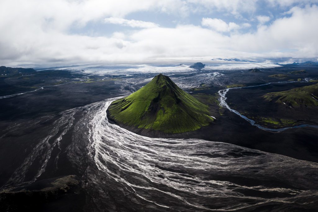
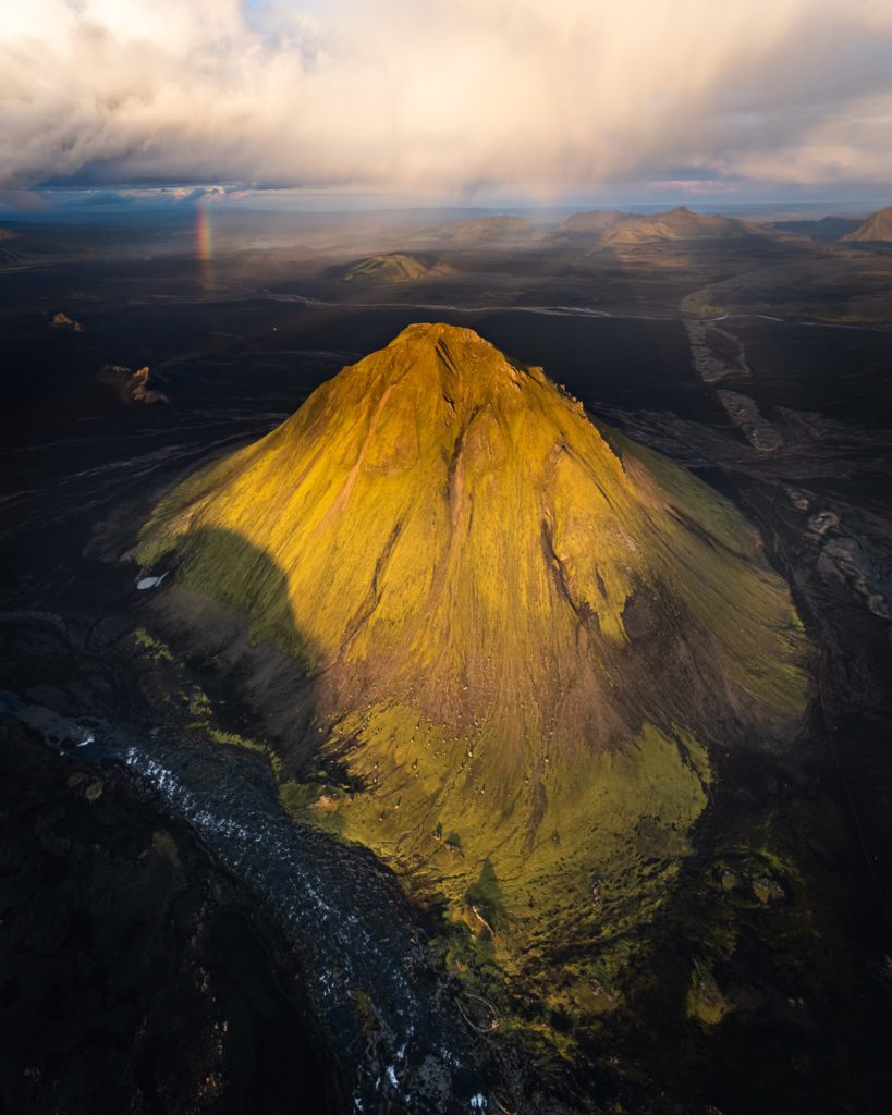
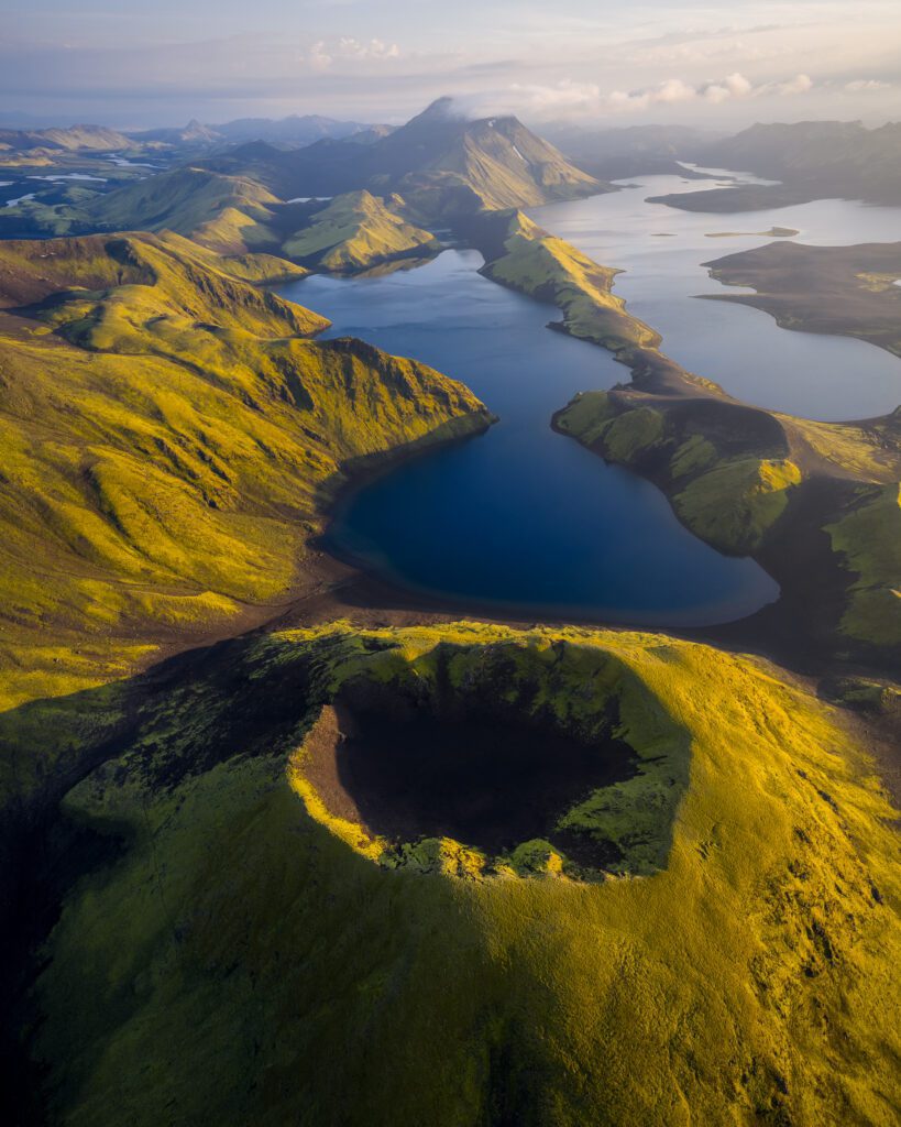
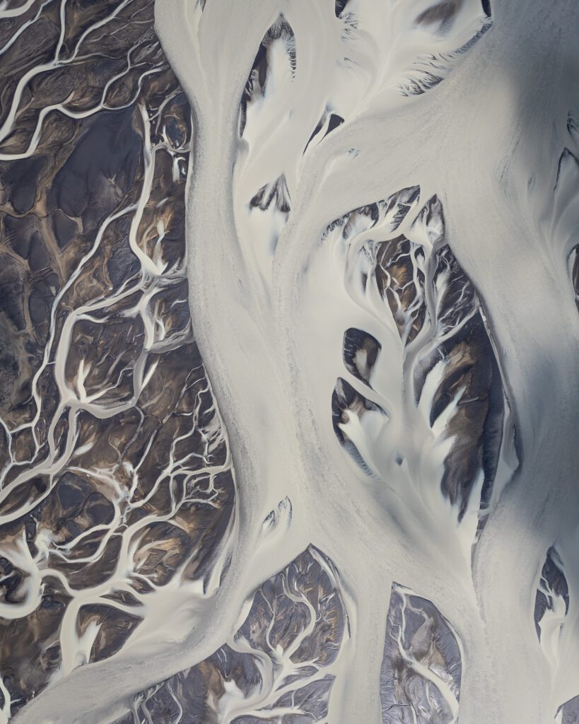
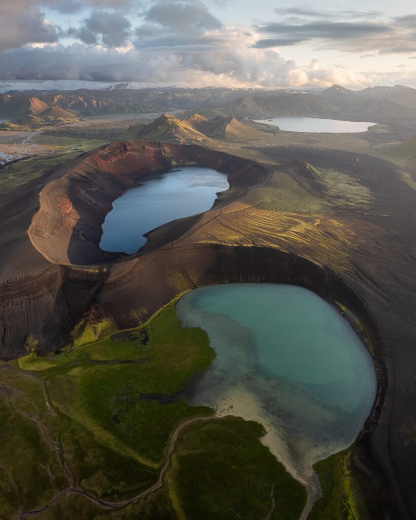
Mælifell. The name might not ring a bell unless you are already deep into Iceland photography, but you have almost certainly seen the photograph. A perfect green cone, sitting alone on a plain of black volcanic sand, with meltwater rivers from the glacier behind it threading through the desert. Black and green, life and death, all in one frame. The whole place has an alien vibe to it.
It took me three attempts to stand in front of it with a camera. The first try, in 2017, I turned back at the river crossing because the water was over a metre deep and there was no phone signal to be found nearby. The second try, in 2020, I made it all the way to the base of the mountain only to watch the cloud cover drop to fifty metres and swallow the cone whole. The third try, the morning after, was the one that worked.
In this article, I want to share how each of those attempts unfolded, the drone settings that finally captured the scene, and the small choice about light and timing that I think is the difference between a Mælifell snapshot and a Mælifell image. Let’s get one thing out of the way first: this isn’t a location you stumble across on a Ring Road loop. Mælifell sits deep in the southern Highlands, and getting there is half the story. This is what this month’s “Behind the Shot” is all about.
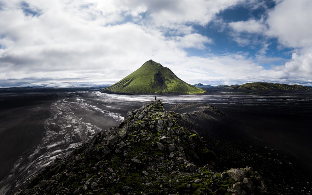
Mælifell is truly a special place in the highlands. The contrast of a massive black sand desert with a lush green cone creates a special vibe. Especially when you take into account how desolate this location really is.
Where Mælifell Sits And Why It’s So Hard To Reach
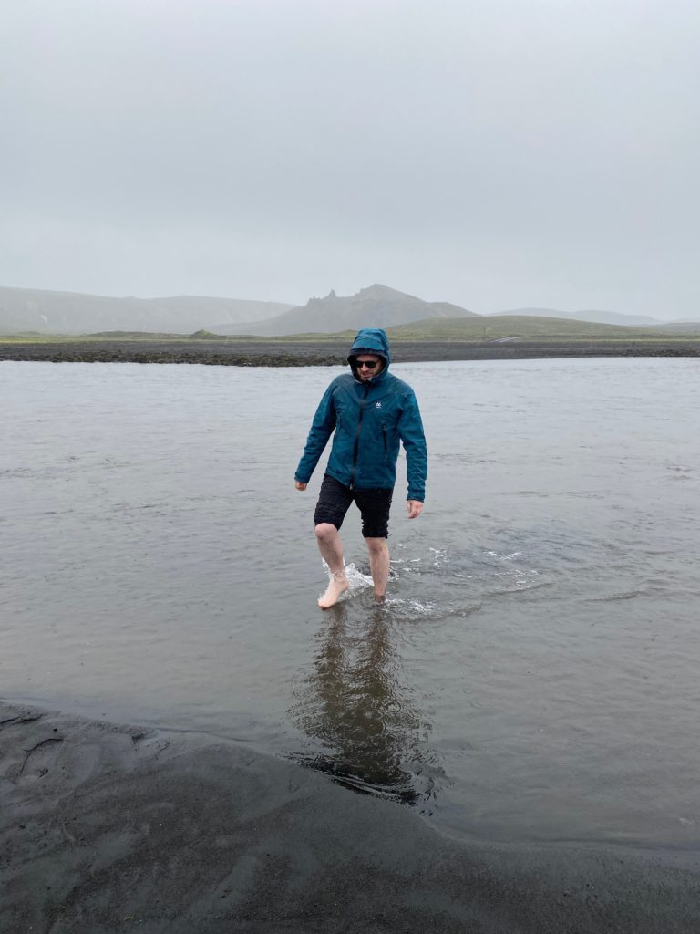
Mælifell sits deep in the southern Icelandic Highlands, on the edge of the Mýrdalsjökull glacier outwash plain. There is no paved road in. To reach it you drive an F-road, normally F210 through Fjallabak, and ford rivers along the way. The largest of those is Hólmsá, which can run anywhere from ankle-deep to chest-deep depending on the week and the weather, and which sits in a stretch of the country with no mobile phone signal.
There is also a season. The moss that turns the cone its iconic green is only at peak colour for a short window, roughly mid-July into early September. Earlier than that and the moss may still be recovering from winter. Later and the first frosts can dull it, and the highlands roads start closing. Photographers who time it wrong end up with a brown cone and a long drive home. Getting Mælifell right is as much a logistics problem as a photography problem.
Attempt Number One
In the summer of 2017, I decided I wanted to start ticking some of the boxes on my bucket list of photography locations in the Icelandic highlands. Travelling in the highlands is very expensive as they are only easily accessible during the high season and require you to have a proper modified 4×4. Therefore I wanted to start modest by only travelling for an extended weekend. The plan was to explore the areas around Kjölur a bit (one of the F-roads crossing Iceland through the highlands) and afterwards drive around Fjallabak all the way to Eldgjá canyon and back. To top things off, I wanted to end the trip with a visit to Mælifell, a location that had been on my list for as long as I knew of its existence.
A few days before I was to embark on this adventure, it started raining pretty much non-stop until the day I was to head to Mælifell. This meant that by the time I arrived at the western bank of Hólmsá (the big river I needed to cross on my route) the water levels had risen to very high levels. After talking to a few horseback riders who were travelling in this remote area, I realised that the water level had increased to more than a metre. While contemplating whether or not to attempt the crossing, I noticed that my phone had no phone signal at the river. This meant that, if anything were to go wrong, there would be no chance to call for help. Therefore I wisely chose not to cross. It was a frustrating moment because I could literally see the mountain on the other side of the river. My trip was halted less than 10 kilometres from Mælifell. I turned around the car and drove back to the Ring Road – wondering when I could try again.
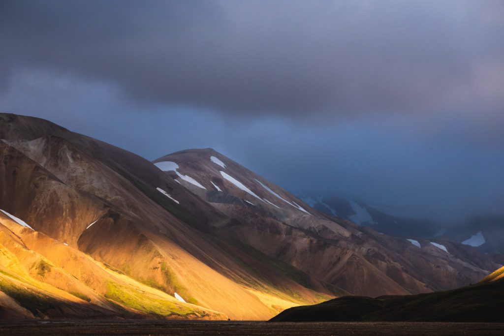
Beautiful light at Landmannalaugar the night before I drove towards Mælifell.
The weather conditions that weekend were excellent. However, the heavy rainfall the week before made the water levels in all the rivers extremely high.
Attempt Number Two
A few years later, in 2020, I planned a 12-day adventure with a friend to explore the highlands in a lot more detail than I had been able to thus far. Because of the pandemic, rental cars and other tourism-related businesses had been struggling to get people to buy their services. Therefore, renting a big 4×4 had become very cheap compared to the years before. This had given me an unprecedented opportunity.
On day one of the trip, the goal was to approach Mælifell from the eastern side by driving behind the Eyjafjallajökull and Mýrdalsjökull glaciers. The weather looked promising at the start and this time I had found an easier route, with smaller rivers, in case the water levels would be too high after the rainfall earlier that week.
Unfortunately, as we got closer and closer to Mælifell the weather became moodier and moodier. After a few hours of driving, we finally arrived at the base of Mælifell. However, the visibility had gotten gradually worse and it had started raining heavily about an hour before we arrived at our goal. The cloud cover had gotten so low to the ground that you couldn’t even see half of the mountain while standing next to it. In hope of the situation improving, we decided to kill some time by having lunch.
Unfortunately, it didn’t improve at all and the conditions got even worse. We cut our loses for that day and continued towards the east. We crossed Hólmsá, which fortunately didn’t have as much water in it as the first time, and continued on a small mountain road towards our destination for the day. In the early evening we reached the campsite where we waited for the bad weather to pass.
The cloud cover had gotten so low that the clouds were only 50 to 60 metres above us. While it didn’t work well at Mælifell, this location did really benefit from such moody conditions.
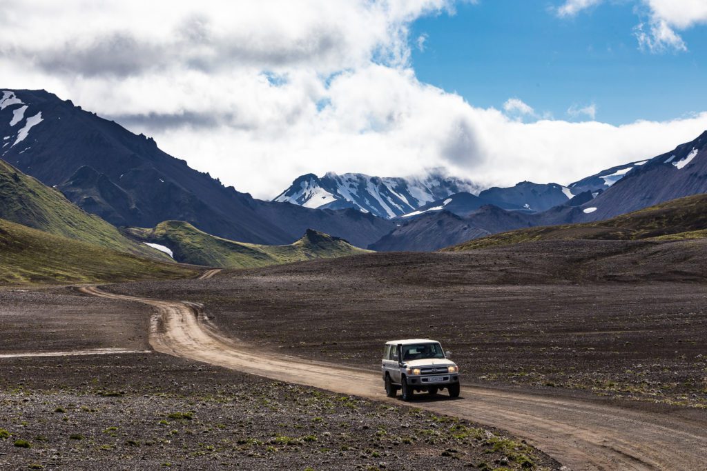
It’s never a bad idea to check the river depth before you drive in but… prepare yourself for ice cold water!
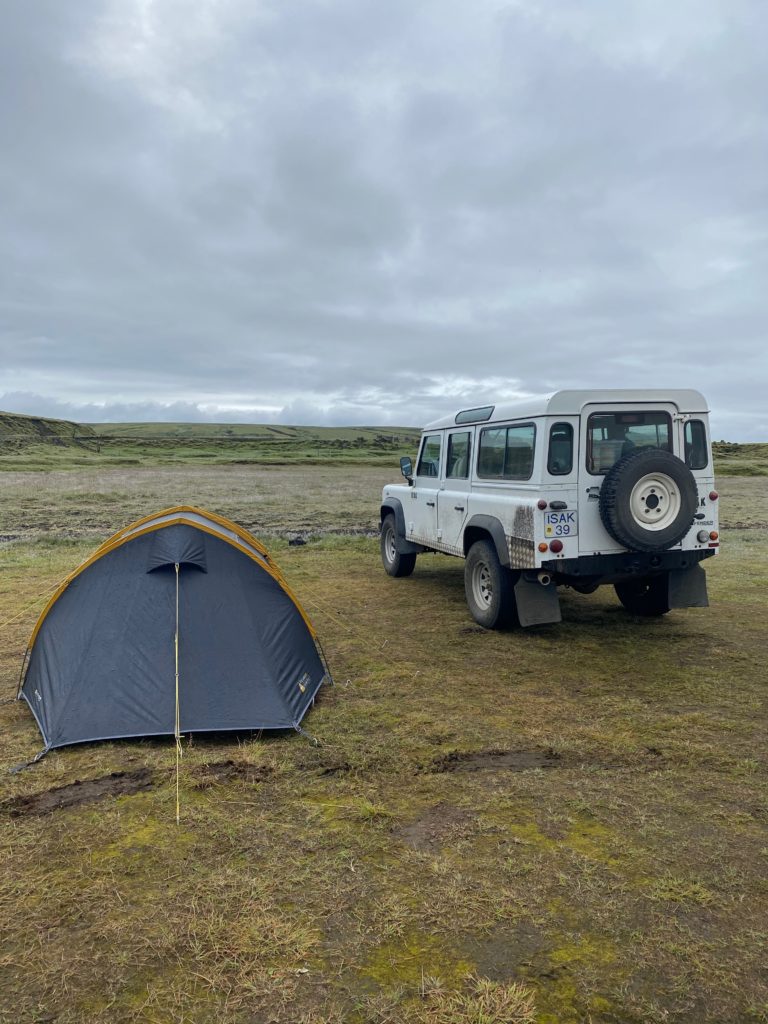
That night we used the car as a shield against the wind. Unfortunately, in the middle of the night the wind direction changed which made the second part of the night a sleepless one.
Attempt Number Three
The next morning, the weather conditions had improved significantly. The rain had finally subsided and the cloud cover had decreased. It felt like my goal was there for the taking. Later that day we crossed Hólmsá again and drove onto the black sand desert towards the mountain. Finally, I could see Mælifell in all its glory.
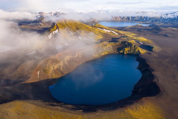
It was even better than I had imagined. Because of the heavy rainfall the day before there was a lot more water flowing through the desert, which created conditions I have yet to see again in this location. The meltwater swirling around the mountain lit up in the sunlight and all over the desert you could occasionally see rainwater evaporating from the sands. It was all I had hoped for and I was very grateful that attempt number three had finally been a successful one. My favourite shot of that moment, is one with an overview of the mountain, the swirling water and the glacier in the background.
Finally I captured the shots I had wanted for such a long time. It feels incredibly rewarding when persistence pays off in such a huge way.
EXIF: DJI Mavic 2 Pro – F/3.2 – 1/1000s – ISO100 (9-shot wide-angle panorama)
The Drone, The Altitude, And The Frame
For full disclosure: I shot this in 2020 with a DJI Mavic 2 Pro. That is two drone generations ago now, and I have since replaced it with the DJI Mavic 4 Pro for everything I fly commercially. I am not retouching the photograph or reshooting it though, and there is a reason for that. The Mavic 2 Pro had a 1-inch Hasselblad sensor, an adjustable aperture from f/2.8 to f/11, and an effective 28mm focal length. That is enough drone for Mælifell. The image is not about resolution or dynamic range, it is about the cone, the moss, and the line of meltwater between them. A newer drone would not have changed any of those.
The EXIF on the final image: f/3.2, 1/1000s, ISO 100, shot as a 9-frame wide-angle panorama and stitched in post. The 9-shot approach is the choice worth pulling out. A single Mavic 2 Pro frame does not have the resolution to print Mælifell large, and the cone is too imposing for the standard 28mm field of view. Panning across nine frames at altitude gave me a wider canvas, a much bigger file, and enough room to crop the composition twice if I changed my mind later.
Something About Firsts
I have since revisited Mælifell a number of times. I was even able to see a truly magical sunset there on one of the photography workshops I guided. However, none of those visits ever came close, emotionally speaking, to that first successful attempt to photograph the mountain. There’s something about “firsts”, and the struggle to achieve them, which makes the memories attached to those photographs timeless.
Whether you experience even more unique or even more incredible conditions, that first time will always linger in your mind. This emotional value you attach to an image, because of a memory or a struggle, is what really makes a photograph to me. It’s what photography is about and exactly what I want to show with my “Behind the Shot” series.
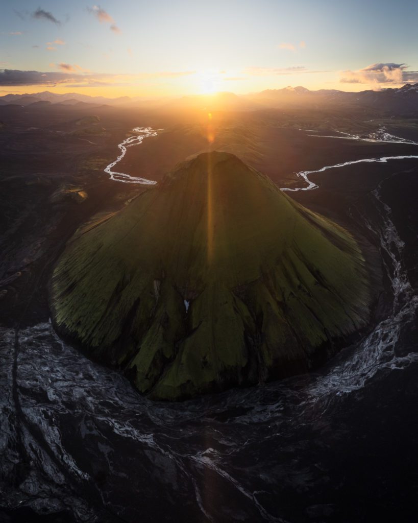
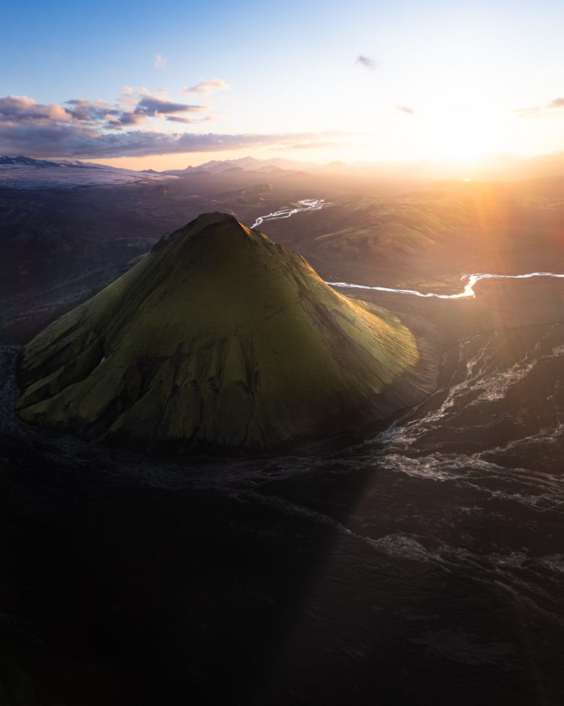
While this sunset session was arguably much more impressive in terms of the conditions to photograph in, it didn’t leave as big of an impression on me as this first successful visit to Mælifell.
Want To Photograph Mælifell With Me?
Mælifell sits in F-road territory, and the moss window is short. If you would rather not spend three days organising a super-jeep, river crossings, and the weather, the easiest way to stand under that cone with a camera in your hand is to join one of my drone photography workshops in Iceland. The Highlands workshop is the one that goes here, in the right week of the year, with the right vehicles.
If you are still picking a drone, my round-up of the best drones for landscape photography in 2026 is the place to start, and the DJI Mavic 4 Pro review is what has replaced the Mavic 2 Pro in my own bag. For everything else on the island, I have mapped my favourite spots in the Iceland Photography Locations ebook, and the highlights live in my top 5 photography locations in Iceland.
DISCOUNT
The Drone Photography Masterclass – Video Course
Nigel Danson & Jeroen Van Nieuwenhove‘s complete drone photography video masterclass will explore everything you need to know to start creating the best aerial photographs using any type of drone in 50+ detailed videos. Whether you are a complete beginner or an advanced drone pilot, this video course contains a vast amount of information to level up your drone photography skills.
What Drone Photography Masterclass Participants Said…
Learn Drone Photography With My E-Book
Want to learn how to get the best results with your newly purchased drone? I wrote the most comprehensive guide available on drone photography which teaches you a technique to get the DSLR-like results out of even the cheapest drones.
In 125 detailed pages I explore everything you need to know to start creating the best photographs using any type of drone. Whether you are a complete beginner or an advanced drone pilot, this e-book contains a vast amount of information to level up your drone photography skills.
What to Expect?
- A 125-page educational PDF about nature drone photography with very detailed explanations
- Which drone to get for photography and why
- Important settings and configuration options
- A list of useful skills & tips
- A list of useful accessories and what not to buy at all
- How to research locations for drone photography
- How to compose with a drone and insight into Jeroen’s thought process with plenty of examples
- Thoughtfully planning ahead for your drone shoot
- The how and why of creating bracketed images
- The how and why of shooting HDR panoramas
- What challenges you might face and how to deal with them
- Common mistakes & how to deal with them
- How to stitch your panoramas together
Use EBOOK20 to get 20% off your Nature Drone Photography (E-Book) purchase!


Discover Jeroen’s Photo Workshops in Iceland, Greenland & Beyond
Ready to take your photography to the next level? Join me, Jeroen Van Nieuwenhove, on unforgettable photo workshops in Iceland, Greenland, Antarctica and other exciting destinations. Whether your passion is wildlife photography, bird photography, landscape adventures, or mastering drone photography, each workshop is designed to give you hands-on guidance in some of the world’s most spectacular locations.
From puffins in the midnight sun to Arctic foxes in the wild, from glaciers and volcanoes to dramatic coastlines seen by drone – these journeys are more than workshops; they’re once-in-a-lifetime experiences. Group sizes are kept small, ensuring personal mentoring and plenty of shooting opportunities.
Looking for something specific? Check out Jeroen’s…
- Wildlife & Bird Photography Workshops (Puffins, Arctic Foxes)
- Drone Photography Workshops
- Photo Workshops in Iceland
- Photo Workshops in Greenland
- Photo Workshops in Antarctica
Spots are limited – secure your place today!
Are You Looking For A Specific Photo Workshop?
All Upcoming Photography Workshops With Jeroen
Explore all upcoming photography workshops with Jeroen and take your skills to the next level in some of the world’s most extraordinary locations. From the volcanic landscapes of Iceland to the ice-filled fjords of Greenland and the wildlife-rich polar regions such as Antarctica, each workshop is designed to help you grow creatively while experiencing unforgettable moments in the field. Browse all upcoming departures below and find your next adventure!
LAST SPOT
OPEN FOR BOOKINGS
OPEN FOR BOOKINGS
WAITLIST
WAITLIST
WAITLIST
WAITLIST
WAITLIST
WAITLIST
WAITLIST
What Previous Participants Shared About Their Experience
Choosing the right photography workshop is about more than just visiting iconic locations. It’s about experience, safety, timing, and personal guidance. Below you’ll find honest reviews from photographers who have joined me on landscape, wildlife & drone photo workshops in Iceland, Greenland and other locations. These testimonials reflect real experiences in small groups, hands-on instruction in challenging conditions, and the level of care Jeroen aims to bring to every workshop.
These reviews are verifiable on Jeroen’s public Google Business profile.


")


")


Support Jeroen’s Work
As an independent photographer, Jeroen partially relies on your support to keep producing worthwhile content such as blogs, photographs, books and much more. If you want to support his work, it is possible to do so by buying his e-books & books or prints.
You can also sign up to the newsletter to stay up to date on new blog posts, projects, workshops and other interesting information.
Thank you for considering!