

Today marks the day the eruption in Geldingadalir has been ongoing for 10 weeks. Come along on my photographic journey capturing the eruption in 10 photographs and videos.
I wouldn’t be exaggerating when I say that this has been dominating my photographic life. At the time of writing, I’ve been up at the eruption site 15 times. During these visits, I’ve been documenting the whole event with a complete focus on the natural aspect of it. It’s been incredible to see the evolution of the eruption and the changing of the surrounding landscape. Every visit I could see how everything changed. It’s as if you are seeing geographical history unfold. In this article, I am sharing 10 of my favourite photography moments in a chronological order.
1. The Birth of the Eruption
Where else to begin than at the beginning, the birth of the eruption. Friday March 19th an eruption began in the Geldingadalir valley on the Reykjanes Peninsula in Iceland. First reports came in quickly and made a note of how small the eruption was. Less than 24 hours later, I hiked all the way from the Blue Lagoon through a lava field, over Fagradalsfjall, to the eruption. Words fall short for what kind of emotion ran through me. Once I saw the eruption appear below in the valley, I almost ran down towards it in excitement. I did my best to describe my experience in a separate blog post. The first footage I wanted to share is a short video I made of the first visit to the eruption area. Up to that point, I had never really dabbled in videography but because this was so special to me, I ended up filming quite a lot.
2. Night Falls
When I set out on that first visit, I had said to myself I wouldn’t really stay until it got dark. This was mostly because of the lack of phone reception in the valley and the poor weather conditions. I should have known that, in all excitement, I ended up staying well after dark. Not only did I lose track of time, I also got mesmerised by the beautiful orange glow the eruption has when darkness falls. I ended up going back to Geldingadalir many times just to experience the magical darkness again. I chose one image and a video. The photograph was taken on the first night and to me it really captures that special feeling of being there so close and personal next to the glowing hot lava in the dark. The footage for the video was taken about a week after the eruption had started on a very cold but beautiful night. By then the two functioning craters had grown a lot which made the show all the more spectacular.
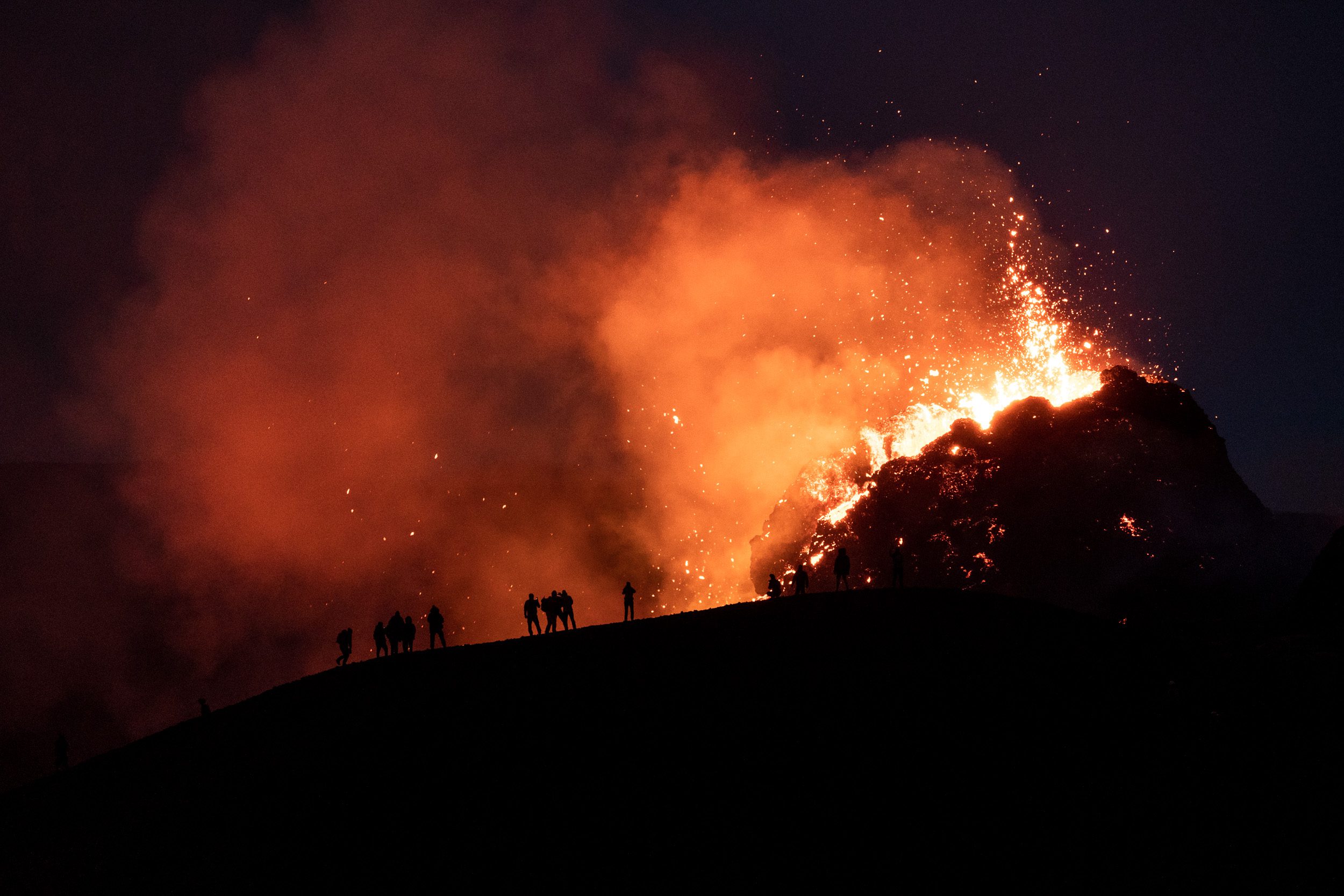
3. Opening of a New Fissure
After about two weeks, a brand-new fissure opened up stretching from the original two craters to the North. The area was closed off almost immediately but reopened two days later. And that is a day I will never forget. I really wanted to see the new action up-close again as I had been a bit bummed about that the original two craters had lost a bit of their “punchiness”. The two craters had collapsed and it had now turned into more of a hole in the ground with lava flowing out of it. A lot less spectacular then what it had been.
So once the area opened up, I decided to go up to the eruption and started out on the eastern side of it. Very shortly after I arrived, after a hike through wet snow and fog, we had to turn around because the wind direction had shifted and the gas levels started becoming dangerously high. However, I didn’t want to give up so I started hiking back to the southern end of the lava field to then hike back up along the western side. That way, I would be up-wind and relatively safe from the gas while still being able to enjoy the new northern craters. The hike was pretty gnarly. Thick fog and snow prevented me from being able to see the original two craters as I walked past them but I could still hear the thundering sound of the lava gushing out of them, all while hiking in a strange orange glow.
Once I arrived at the northernmost crater, night had fallen. The atmosphere was incredible. I stood close to the new crater, feeling the heat of the lava shooting out of the crater while feeling ice cold snow in my face. Suddenly the flow exiting the crater changed direction and started flowing towards the side I was standing. In-cred-i-ble! The lava churned forward while I was taking photo after photo. The thrill of being this close to the action, this close to the lava flow, just blew my mind.
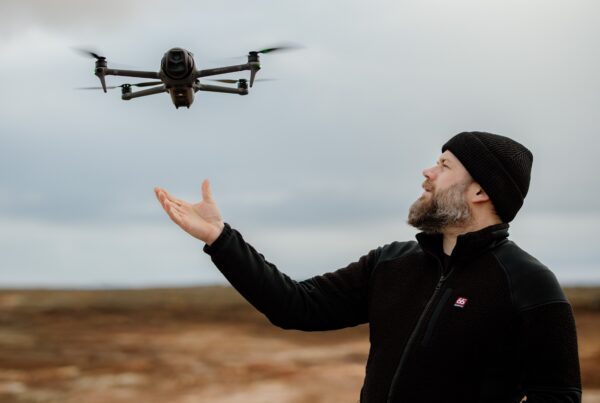
4. A Look From Above
After all the excitement of the initial visit after the new fissure opened up, I started going through my shots in more detail and I realised I hadn’t really bothered flying my drone much. Mostly because I enjoyed being there on the ground next to the action. The next few visits, I spent a lot of time with my drone: capturing the craters up-close, focusing on the patterns and smaller details that were only visible from the air. It’s incredible what these tiny flying cameras can show you – especially in an otherworldly environment such as this one.


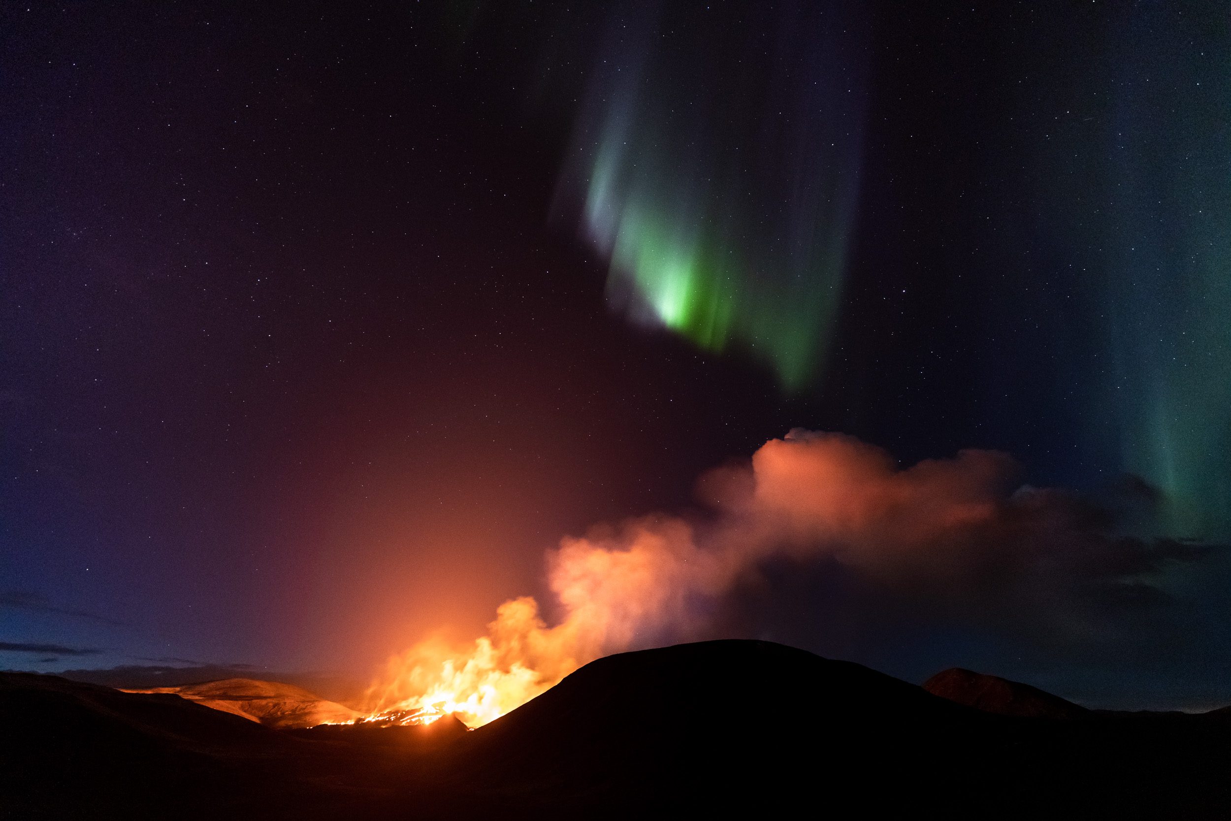
5. Volcanic Aurora
By now the eruption had been ongoing for several weeks. All that time I had been thinking a lot about whether or not the opportunity would present itself to photograph the northern lights above the eruption. I considered, and still consider, that to be sort of the “holy grail” for landscape photographers in Iceland as it’s a situation that brings together two of the most iconic natural phenomenons in Iceland in a single image. If you’re interested in the full story, I have already written that up in a blog article.
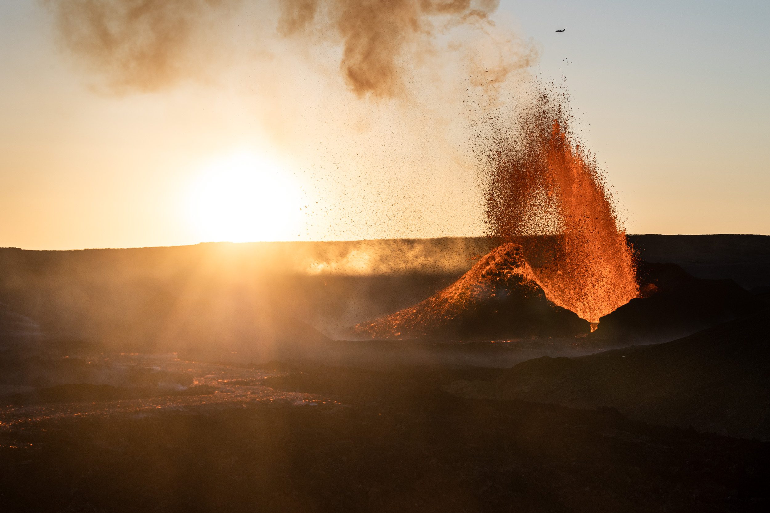
6. A Lava Geyser
Then the eruption started changing dramatically. Most craters started shutting down one after another, while the amount of lava exiting the functioning craters started increasing. The latest crater that appeared in the eruption became the only functioning one and started growing and growing… Then suddenly it’s behaviour changed overnight. The lava fountain turned into a geyser, erupting with 7-8 minute intervals to heights of 200-300 metres. Again the eruption changed so much that I just had to be there to capture its next phase. I hiked up on a mountain in a nearby valley to get a good look from a distance. The height was necessary to get as little as possible distortion in the air from the rising heat from the lava field. And then it just aligned for me: the smoke, the setting sun, an airplane flying overhead to add a bit of scale, … Everything just worked and I ended up with this stunning photograph.
7. The Main Crater
Now that there was only one crater which was actively erupting, I took it a bit as a challenge. It felt as if the eruption had thrown me a curveball and I just answered its call. Challenge accepted! But how to photograph this one erupting crater in different ways? I started hiking around the lava field to the western side where almost no one else went and tried out many different angles. I also started incorporating the moss fires in my photographs, which had been started by hot lava landing into the vegetation. Below you can find a few of my captures. It’s the same enormous crater from different angles and in different settings.


8. Scale
With the lava fountain shooting higher and higher, I wanted to try something different. I wanted to try and capture the scale of it, which is not straightforward because you can’t really put anyone right next to it. I started out with trying to photograph my friend’s silhouette while we were both on the mountain side, which didn’t really give me the desired effect. Though the photograph looked very impressive, it didn’t really do the scale of it all justice. So I ended up hiking back down into the valley until I was about 1 kilometre from the erupting crater. There I could see the tiny people standing on the mountain, while the lava was shooting up behind them. Because I couldn’t see the crater from where I was sitting, I was relying on the light coming from the lava to know when it would go off. When it starts to erupt, you can see the whole area light up with orange light as if you would be standing in a massive city. I spent about 40 minutes photographing there until I got the shots I was happy with. Because the height of the erupting lava always changes, I had to give it several attempts.


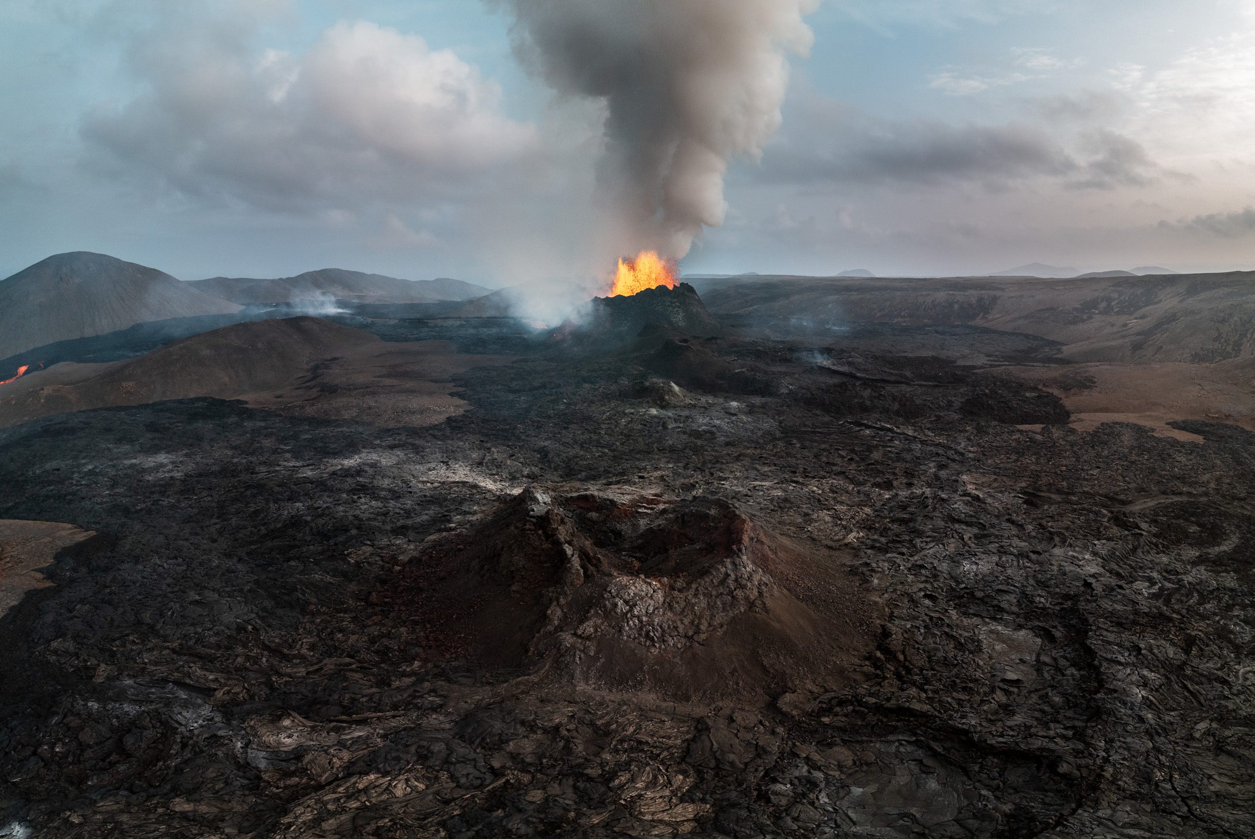
9. Past and Present United
It’s not every day you can combine history with current events in one image. In the photograph below you can see the northernmost crater at the bottom, which has stopped erupting a few weeks ago. At the same time, you can see the current erupting crater in the back of the images. To me it’s as if we are looking into history. Throughout the country you can see many of these solidified eruption craters, which leaves it up to you to imagine what that must have been like when it was still erupting. Now it was possible to see both “old” and “current” in one image without needing the help of any Photoshop magic. I feel this is the most interesting thing about the eruption. It’s not the lava shooting hundreds of metres into the air, or the fast-moving lava flows or even experiencing the heat and sounds. To me it’s a lot more about history in the making in front of your eyes, it’s experiencing the constant changing of the landscape as it starts to settle and solidify. How many times in your lifetime do you get to witness our planet being formed and shaped up-close and personal like this?
10. Inside the Crater
The past two weeks, I’ve been focusing on the insides of the crater and also photographing more patterns in the ever expanding lava field. Because the crater has grown so big, and it has this geyser-activity, it’s been incredibly interesting to document what’s going on inside of it. I’ve made several photographs looking at the insides and even filmed the whole eruption from a safe height. It’s always a bit of a gamble to fly with your drone above and around an active eruption. Truth be told: I really don’t know how close I can get and every time I tend to become a little bit riskier with flying it close. It’s impossible to know how high above the lava you actually are as you can only see the height relative to where you took off. Below are a few of my latest drone-made captures. I love looking for patterns within the lava field. Can you recognise the eye and the dragon’s head & neck?


What’s next?
The one-million-krónur question that’s on every photographer’s mind these days is: “When will it stop?”. We don’t know when it will stop but geologists are fairly confident it will go on for several more months, if not years. The prospect of having this eruption around for a long time makes my photography heart beat fast. The excitement of dreaming about what photography material I might capture next, keeps me returning again and again to the eruption site.
For those who are interested, I’m also selling prints of some of these eruption photographs in my webshop. Please also feel free to check out my work on my Instagram profile and Facebook page.
Support Jeroen’s Work
As an independent photographer, Jeroen partially relies on your support to keep producing worthwhile content such as blogs, photographs, books and much more. If you want to support his work, it is possible to do so by buying his e-books & books or prints.
You can also sign up to the newsletter to stay up to date on new blog posts, projects, workshops and other interesting information.
Thank you for considering!


Fantastische fotoreeks Jeroen. Echt jaloers dat ik niet in IJsland woon 🙁
groetjes vanuit Zwitserland
www.nicklauvrys.com
Bedankt Nick! Blij te lezen dat je er van genoten hebt.
This is absolutely an amazing collection of video and pictures ?? And so great with your story. I’m even more looking forward to go out there with you and experience it ?????
Thank you so much Anja! Looking forward to visiting the eruption together with you!